Quantcast
Channel: RTK – GPS World
Viewing all 129 articles
Browse latest View live

Expanded GNSS and 5G: A gift for the surveyor

$
0
0

Regular readers of GPS World are aware of many of the rapidly developing technologies and navigational systems being created around the world, but often the everyday surveyor shows up late to the party.

While smartphones get the most mainstream media coverage, other navigational devices and measurement systems are adapting to evolving technical breakthroughs and new methods of transmitting a variety of data wirelessly.

This month’s article looks at the increase in satellite navigation networks along with the rollout of 5G cellular technology. Both advancements will benefit the surveying community; to start, I’ll explain what this means for accuracy and precision of survey measurements as well as productivity.

Everybody gets a constellation! (with apologies to Oprah)

I’ve been known to wax poetic in this column about my admiration of GNSS technology, and I continue to marvel at the “accidental” civilian use of a military tool. This method of measurement and navigation continues to expand, refine and transcend everyday life, and surveying is no exception.

The satellite constellation is the mainstay of this navigational system. The United States began the charge several decades ago, but other nations are quickly catching up. Let’s look at the current constellations and their status.

Operational Systems

  • GPS (United States)
  • GLONASS (Russia)
  • Galileo (European Union)
  • Beidou (China)
  • QZSS (Japan)
  • IRNSS (India)
Chart: GPS World

Chart: GPS World

There are now more satellites. What’s the big deal?

The addition of these constellations provides large gains for the surveying community in several different ways.

First, the additional satellites mean more signals to help with the mathematical equations necessary for positional determination. While traditional surveying in the general public’s eye is associated with measurements on the ground, our expansion of services into the air and water relies heavily on GNSS determined positions.

No matter what type of remote sensing equipment is being used (lidar, photogrammetric, sonar, etc.), positional determination for most of those sensors are derived from GNSS-based receivers. Add to these measuring methods the ability to perform operations via remote-controlled or autonomous vehicles in both air and water, and the availability of additional satellite signals enhances the reliability of GNSS-derived data and attributes.

Second, by having more satellite signals to utilize, GNSS receiver manufacturers can improve the software for processing the positional information with greater certainty of accuracy.

Before the introduction of additional constellations and receivers with expanded signal reception, GNSS users relied on less sophisticated software to identify potential “bad” signals that would lead to incorrect positions. While the software generally provided reasonable reliability, it was not foolproof and occasionally would allow bad data to be accepted.

Like most everything tech-related, however, the GNSS industry has benefited from increased computing power to go along with the additional satellite constellations. The latest GNSS receivers can accept well over 500+ signals from a variety of sources (including land-based transmitters). The software used to reduce all that data has increased in complexity along with number of those data sets.

Complex computations that were once limited to mini-computers or even mainframes are now being completed on handheld data collectors in minuscule timeframes compared to their predecessors.

The software has also been enhanced to analyze the data in real-time, compute the likely position of the receiver and notify the user of potential incorrect or “spoofed” data from any number of satellites.

Considering that many of the remote-sensing sources now collect millions of points based upon one GNSS-based position, the need for increased positional verification has become a critical issue. By having many more constellations to provide signals for positional data, the percentage of establishing a correct location for each data point has increase significantly.

The improved computing power and verification ability of today’s GNSS software is helping to eliminate errors in positional accuracy and instill more confidence in the surveyor’s data collection activities.

Add to these additional constellations the planned installation of more land-based signal providers to augment or provide a backup plan for satellite systems, and it’s clear that the future is quite bright for GNSS-based receivers and data collection for everyone — especially the surveying community.

The history of wireless communication

While surveyors marvel at the advancements of GNSS-based measurement, it pales in comparison to the rapid growth of modern technology with cellular devices. Notice I didn’t write cellular phones, as the technology has quickly established itself as much more than voice communication. Before we lay out the future of cellular data networks, let’s take a step back and see how this type of communication has revolutionized GNSS-derived data collection for surveyors and others.

Two-way, CB and shortwave ham radio

1947 two-way radio advertisement. (Image: Motorola)

1947 two-way radio advertisement. (Image: Motorola)

The technology behind wireless communication goes back several decades, but didn’t become a mainstream system until the late 1970s and early 1980s. Motorola is known as the early force behind the two-way radio system, but the base and remote transmitters were not cost effective for small businesses. This type of system was also limited to single-purpose radios with individual crystals wired within that only allowed specific frequencies to be transmitted.

Another type of communication used by some was the citizens band radio, affectionately referred to as CB radio. This radio was limited to 40 channels and didn’t allow for private transmission between two parties. During the 1970s, the use of the CB radio was not limited to long-haul truck drivers — many people used the medium for basic communication.

Vintage CB radio ad from Radio Shack. (radioshackcatalogs.com)

Vintage CB radio ad from Radio Shack. (radioshackcatalogs.com)

Telephone service during these times was still costly and long-distance calls were not cost-effective, so many found the CB radio as an alternative to conventional phone service. Looking back now, it is not a stretch to classify this type of broadcasting as a primitive social media precursor to today’s methods but limited to live chats and no visuals.

Another method of transmission was short-wave radio. This system was like two-way radios with an established base transmitter, but broadcast on public frequencies over greater distances than CB radios. One of the big drawbacks was the upfront costs, which were much more significant than the other radios. Even more expensive was outfitting a vehicle with a shortwave system, so cost was the biggest limiting factor for this mode of communication.

Pagers of all shapes and sizes

Motorola's Pageboy pager. (Photo: Motorola)

Motorola’s Pageboy pager. (Photo: Motorola)

The popularity of telephone-based pagers didn’t hit its zenith until the early 1990s, but the technology and actual use dates to the early 1960s. The first commercial pager was produced by Motorola in 1964 and called the Pageboy. There was no screen or display; the user was notified by a variety of tones preset for distinct situations or needs. As this technology advanced, variations in screens, message types and even two-way communication became possible.

By 1994, there were more than 60 million pagers in use, but a change was in the technological wind; cellular phones were marching toward the mainstream.

Cellphones on every street corner

Motorola DynaTAC 8000X portable cellular phone, 1984. (Photo: Motorola)

Motorola DynaTAC 8000X portable cellular phone, 1984. (Photo: Motorola)

While the concept of wireless telephone communication existed in several laboratories around the world for years, the first big breakthrough was made by researcher Martin Cooper, who developed a prototype cellular device for Motorola in the early 1970s. He famously made the first public cellular phone call on April 3, 1973, to Joel Engel, head of research at Bell Labs, during a walk in New York City. Cooper and Engel were engaged in a rivalry to develop the first commercially available cellular phone with the Motorola DynaTAC prototype being the first to make a successful call.

However, the rush to get cellular phones to market took longer than anticipated. It wasn’t until the introduction of the Motorola DynaTAC 8000 in 1983 (available to the public in March 1984) that the reality of wireless phones came to life. The cost of wireless freedom came at a price: $3,500 for a brick-sized phone that took 10 hours to charge for 30 minutes of use. The cost of the service was also expensive due to the limited cellular infrastructure.

The next decade brought us expanded cellular coverage along with miniaturization of phone; each subsequent model provided more features and longer battery life. From the Nokia “candy bar” to the Motorola Razr, the cellphone era had engulfed the mainstream, but more changes were ahead for mobile communications.

The late 1990s saw the introduction of the cellphone as a computer modem, with limited email connectivity and primitive internet browsers built into the operating systems. But like many electronic technologies that came before, the cellphone would begin a radically different life in the mid-2000s.

Enter the smartphone to help us dummies

The IBM Simon Personal Communicator and charging base. (Photo: IBM/public domain)

The IBM Simon Personal Communicator and charging base. (Photo: IBM/public domain)

Officially, the smartphone has been in existence since 1992 with the creation of the Simon Personal Communicator from IBM. At a cost of $1,100, with a monochrome screen that was 4 ½ x 1 ½ inches, the Simon allowed the user access to email and faxes (remember those?) along with the phone function — but users had to make it fast; the battery only lasted an hour. IBM sold 50,000 of these units before pulling the plug on the project, but it started the trend toward mobile telephones with a graphical interface and extended uses beyond the standard verbal communications.

Just like the Apple Newton was the failed precursor to the Palm Pilot, various tablets and eventually today’s smartphone platform, the Simon broke ground and established new directions for future communication.

The early 2000s introduced us to the Blackberry personal digital assistant (PDA) and phones from Research in Motion (RIM), a small electronic communications company from Ontario, Canada. RIM started small with a two-way paging system that became popular in Europe and quickly morphed into cellular devices that worked on the DynaTAC network used by Motorola.

A recent model Blackberry PDA. (Photo: Blackberry)

A recent model Blackberry PDA. (Photo: Blackberry)

By the mid 2000s, their devices became affectionately known as the “Crackberry” as users became addicted to the functions and capability of this communication tool. These devices were popular with business users as the security encryption was considered more effective than any of the other communication apparatuses of the day.

By 2009, Blackberry had reached the zenith of the mobile device market (second only to the conventional mobile-phone platform dominated by Nokia) but began a rapid decline due to proliferation of the next big thing — the touchscreen smartphone.

After Apple’s introduction of the iPhone in 2007, followed by a crowd of Android-powered phones in 2008 and beyond, Blackberry’s market share has been reduced to a small niche group.

And now, why this relates to the surveyor…

The rollout of Steve Job’s dream of combining Apple’s industry-defining iPod with mobile phone capability revolutionized not only the way we communicate — it has redefined our everyday environment. Many of the tasks we accomplish every day have been incorporated into a smartphone application, which brings us back to the reason this article is directed at surveyors: the device that hangs on your belt or rests in your pocket is revolutionizing the way today’s surveyors work.

Not that long ago, the only navigational devices available were large, expensive and difficult to use. Now, nearly everyone owns a device with GNSS capability. When we combine the ever-expanding number of devices along with the increased coverage of GNSS satellite constellations, the ability to georeference any piece of data to greater precision and accuracy is improving.

Surveyors need to embrace this technology within their smartphones to increase their efficiencies. At the same time, we need to help educate the public on why having better smartphone location capability doesn’t mean the masses can perform their own boundary analyses. For more information on this subject, see the GPS World July 2017 article.

Surveyors should embrace the smartphone as an important tool; the introduction of new survey-grade GNSS receivers that use an app for the user interface will soon become commonplace.

Several GNSS manufacturers have introduced receivers that exclusively use a smartphone and app for data collection, eliminating the need for a dedicated (and usually proprietary) data collector for obtaining centimeter-level location data. I’m not advocating that the surveying community throw their existing systems in the trash in favor of these newer receivers, but the data-collection techniques utilized by smartphones can increase efficiency and reduce equipment costs.

The Mi 8 smartphone offers dual-frequency capability. (Image: Xiaomi)

The Mi 8 smartphone offers dual-frequency capability. (Image: Xiaomi)

Another reason to pay attention to the smartphone as a location tool will be the expanded use of dual-frequency chipsets to provide even higher accuracies. One of the fastest growing phone makers worldwide is Xiaomi, based in Beijing, China, which introduced the Mi 8 phone with a dual-frequency GNSS chip. This chip frequency reception (E1/L1+E5/L5) is targeted to embrace the Galileo and GPS constellations for increased accuracies (within a decimeter),  well beyond the current norm for smartphones (typically 1-3 meters, plus or minus). For the surveyor, having this capability in their pocket can greatly increase efficiencies, especially when used during reconnaissance efforts. I believe many more phone manufacturers will begin to incorporate dual-frequency chips in their future models to increase location accuracies for users and take advantage of upcoming network enhancements.

Speaking of network enhancements, let’s talk 5G as a gamechanger.

The latest buzz in the general population’s lexicon is 5G and how it will push high-speed internet to all corners of the world. While this is a possibility, it means much more to the surveyor than meets the eye. Yes, there will be increased cellular coverage in places that previously lacked it, or only had limited access, but 5G means much more than that.

Image: NTT DOCOMO Inc. 5G white paper.

Image: NTT DOCOMO Inc. 5G white paper.

Let’s refresh our view of what cellphone coverage currently means to the surveyor. The use of cellular-based RTK receivers has been greatly expanded due to the increased coverage of 4G LTE signals throughout the world, but it’s still scarce is some parts. This is mostly due to the transmission of cellular signals being required from towers and higher placed antennas with powerful transmitters. These transmitters are costly and typically owned and installed by the larger telecom companies, so placement is traditionally in more populated areas.

Enter 5G — while it will provide enhancements for all users, it will be revolutionary for the surveyor. 4G cell coverage was a broad and powerful signal from large transmitters; 5G cellular service consists of smaller cell signals placed in a tight grid of broadcast positions. These transmitters will be more cost effective for many telecom providers and will increase data reception for many users. For surveyors, the additional coverage of 5G will make possible the use of cellular-based RTK GNSS data collection in places not previously possible.

Besides the extended coverage of 5G, the 10-fold speed of the new data transmission protocol compared old 4G LTE creates many possibilities for information collection growth. Soon it will be possible for a field personnel and the office staff to be linked in real time during the data collection process.

From boundary-point recovery to complex topographic surveys, a field crew’s work can be supervised and reviewed while being completed, allowing for instantaneous analysis and guidance from senior staff. This process will allow for more oversight, quality control and mentoring of field staff than is possible for today’s remote crew operations. The new technology will also allow for reduced timeframes when crews are required to provide field data for tight deadline requests and gives us a method of instant feedback on the amount and quality of the data collection.

Some may see this improvement in connectivity as an avenue for office staff to be intrusive on their field activities, but I see this as an opportunity for improved quality control and increased team interaction. More connected teams can lead to improved efficiencies and overall increases in productivity, profitability and morale among team members.

From outside to inside

Another breakthrough created by 5G will be the enhancement of indoor georeferenced location services. By having several transmitters placed throughout a facility, trilateration will be possible to provide more accurate location information for places not typically available to surveyors.

Depending on the accuracy needed and placement of the cell providers, it will possible for surveyors to use devices designed for remote sensing (laser scanners, lidar, SLAM, etc.) and collect georeferenced data with greater accuracy in relation to a known coordinate system. This by-product will also aid rescue and medical providers during emergencies to help pinpoint individuals through their cellphone connection more accurately than before.

5G is more than just bringing YouTube videos to your phone faster; it will improve the data collection process of all shapes and sizes. Surveyors will not get left out, but we will need to be ready to take advantage when it comes online. For more on the 5G revolution, see the GPS World February 2018 article on this topic.

As surveyors, just when we think that technology can’t take us further, we blink and change happens. Moore’s law stated (depending on which revision) that technology would double the number of transistors every one to two years. While some may say that technology is making Moore’s law obsolete, I believe the creativity being used to invent new processes based upon the technology is holding strong.

I, for one, look forward to many more enhancements to follow in the coming years. Surveyors be ready; the future is here.


Galileo satellites to bring boost to Case IH AFS RTK+ users

$
0
0
Image: Case IH

Image: Case IH

Agriculture equipment maker ​Case IH is enhancing the robustness of its RTK+ correction signal network by adding the European Galileo system to the compatible satellites with which it works.

The move will increase levels of signal reception and reliability for farmers using Case IH RTK+-guided autosteering and related technologies.

Real-time kinematic (RTK) systems typically depend on signals from the American GPS or Russian GLONASS satellite networks, both designed primarily for non-civilian use. To give European Case IH users a reliable alternative when using RTK+-guided steering systems with their sub-1.5-centimeter repeatable accuracy, Case IH AFS RTK+ now also uses Galileo.

The addition of Galileo to the global GNSS constellation helps minimize the risk of signal failure, a key driver for the integration of its signals into the Case IH AFS RTK+ signal system. European satellite network independence is a principal objective, but Case IH AFS RTK+ is also designed to be compatible with existing and planned GNSS satellites and interoperable with GPS and GLONASS.

Galileo benefits farmers by minimizing downtime from waiting for lost signals to be regained, and ensures consistent efficient use of seed, fertilizer and crop protection products through parallel passes with minimal overlap, thereby maximizing crop potential.

“The use of GNSS technology is opening up new productivity levels and opportunities in European agriculture, providing farmers with an unprecedented level of knowledge about their crops, livestock and operations while making the sector more efficient, economically competitive and environmentally sustainable,” said Maxime Rocaboy, product marketing manager, AFS technology, at Case IH.

“Enhanced RTK+ accuracy through incorporation of signals from the Galileo satellite system is a core way in which we can help Case IH tractor and combine users be innovative and competitive as they seek to help develop a sustainable agriculture to feed an ever-increasing world population in an environmentally responsible way,” Rocaboy said.

Ag Leader launches GNSS smart antenna for precision agriculture

$
0
0

Ag Leader has unveiled new guidance and steering solutions for precision agriculture, including a dual-antenna automated steering system and the latest in GNSS technology.

The GPS 7500 GNSS smart antenna. (Photo: Ag Leader)

The GPS 7500 GNSS smart antenna. (Photo: Ag Leader)

The GPS 7500 is a field-ready, multi-frequency GNSS smart antenna providing the latest technology including access to multiple GNSS signals for up to sub-inch accuracy and increased performance in variable terrain.

When combined with NovAtel’s TerraStar-C PRO differential correction service, GPS 7500 receives multi-constellation support for better satellite availability.

A full range of performance accuracies are available from GLIDE to RTK, offering a variety of solutions for customers. Combined with SteerCommand, the GPS 7500 offers sub-inch real-time kinematic (RTK) accuracy using the Relay 400, Relay 900 or InCommand NTRIP Client.

The receivers with InCommand software. (Photo: Ag Leader)

The receivers with InCommand software. (Photo: Ag Leader)

Wi-Fi capability within GPS 7500 allows for base-station configuration from a smartphone or tablet.When uptime is valued over absolute accuracy, integrated StableLoc technology utilizes available correction signals to provide a seamless transition between correction sources — without position jumps — and maximize signal uptime.

“SteerCommand with DualTrac brings a dual-antenna offering to the market that provides RTK accuracy and meets the needs of many farmers requiring high-accuracy automated steering at low speeds,” said Bill Cran, Ag Leader product specialist. “New GNSS technology in the GPS 7500 was leveraged to make this possible and also adds new satellite and correction offerings including TerraStar-C PRO.”

The GPS 7500 supports the new TerraStar-C PRO service, available in 3-month and 12-month subscriptions. TerraStar-C PRO offers multi-constellation/multi-frequency positioning with greater accuracy, availability and reliability than before. Its convergence is 60-percent faster and accuracy 40-percent better than TerraStar-C to overcome challenging signal conditions such as multipath, shading, interference and scintillation.

SteerCommand with DualTrac. Combining the GPS 7500 receivers with SteerCommand and InCommand displays offers automated steering control with sub-inch accuracy at ultra-low speed (as low as 0.05 mph). SteerCommand with DualTrac is designed for operations requiring precise steering such as planting or harvesting bedded crops, installing drip tape or planting and harvesting specialty crops. It provides a stable heading, even when the vehicle is not moving, as well as rapid line acquisition in forward or reverse.

Septentrio launches tiny Mosaic high-precision GNSS module

$
0
0

Septentrio has launched the Mosaic high-precision GNSS receiver module.

Despite its compact size (31 x 31 x 4 millimeters,  1.29 x 1.29 x 0.15 inches), the Mosaic module supports more than 30 signals from all six GNSS constellations, L-band and various satellite-based augmentation systems, the company said.

As a multi-band module tracking all GNSS satellites in view, it is also designed to support future GNSS signals.

It also supports correction services, and uses real-time kinematic (RTK) technology, together with Septentrio’s algorithms, to guarantee maximum accuracy and availability. The surface-mount design of Mosaic is optimized for automated assembly and ease of integration, with a full library of well-documented and flexible interfaces.

“Our new Mosaic module represents the best-in-class option for reliable and scalable position accuracy, with integrity,” said Chris Lowet, product manager at Septentrio. According to Lowet, it provides RTK positioning with a power consumption of 0.6-1 W, and requires no or minimal additional components for the design-in. “These characteristics make it an ideal positioning cornerstone for a variety of mass market UAV, autonomous and robotics applications,” Lowet said.

Photo: Septentrio

Photo: Septentrio

Robustness to interference. Due to the natural weaknesses of distant GNSS signals and a crowded radio-frequency spectrum, GNSS-based services are vulnerable to unintentional radio-frequency interference (RFI). They are also vulnerable to intentional RFI, attacks intended to disrupt receivers by means of counterfeit GNSS-like signals (known as spoofing), and to intentional transmission of RF energy to mask GNSS signals with noise (known as jamming).

To defend against these threats, Mosaic features Septentrio’s AIM+ technology. AIM+ can suppress the widest variety of interferers, from simple continuous narrowband signals to complex wideband and pulsed jammers, the company added. In addition, the integrated spectrum analyzer allows the RF environment around any Mosaic module to be viewed in real time in both time and frequency domains.

Effective interference countermeasures against threats to GNSS signals also require constant knowledge of the changing RF environment. The Mosaic module helps analyze these threats by continuously and automatically monitoring the GNSS frequency spectrum to detect, characterize, log and mitigate interference events when needed.

Tersus introduces Oscar GNSS RTK system

$
0
0
Photo: Tersus GNSS

Photo: Tersus GNSS

Tersus GNSS Inc. has launched Tersus Oscar, its new generation GNSS real-time kinematic (RTK) system.

Oscar is an all-in-one GNSS receiver that can be used as rover or base system. Paired with a Tersus TC20 controller or A11 mobile terminal, Oscar can more efficiently meet customer application requirements for the optimal surveying solution, according to Xiaohua Wen, founder and CEO of Tersus GNSS.

“Last year, we launched the David GNSS receiver,” Xiaohua said. “This year, we are very excited to introduce an advanced version of David; we named it Oscar.”

Oscar supports calibration-free tilt compensation function, meaning a leveling pole is no longer required. Configuration is made easy with a 1.3-inch interactive screen. With an internal high-performance multi-constellation and multi-frequency GNSS board, the Oscar GNSS receiver can provide high accuracy and stable signal detection, the company said.

The high-performance antenna can speed the time to first fix and improve anti-jamming performance. The built-in large capacity battery can support up to 10 hours of fieldwork.

A radio module in the package supports long-distance communication. With its rugged housing material, Oscar is protected from harsh environments.

CHC Navigation releases all-in-one GNSS RTK solution

$
0
0
The i50 GNSS receiver comes bundled with the CHC HCE320 Android controller and CHC LandStar 7 field data collection software. (Photo: CHC Navigation)

The i50 GNSS receiver comes bundled with the CHC HCE320 Android controller and CHC LandStar 7 field data collection software. (Photo: CHC Navigation)

CHC Navigation has unveiled its i50 GNSS receiver, an all-in-one GNSS RTK solution.

The GNSS receiver comes bundled with the CHC HCE320 Android controller and CHC LandStar 7 field data collection software. According to the company, it is a cost-effective solution for topographic and construction positioning tasks in land surveying, small- and medium-sized construction projects, and precision GIS data collection.

“The i50 GNSS is designed to match the demand of cost-conscious yet demanding professionals searching for one all-in-one GNSS RTK survey solution,” said Hans Huang, product manager of GNSS solutions for CHC Navigation. “By integrating field proven GNSS positioning and communication technologies in a compact and rugged unit, land surveyors will experience unmatched work flexibility in their daily field work with CHC i50.”

Hemisphere highlights RTK products and solutions at Intergeo 2018

$
0
0

Hemisphere GNSS’ Miles Ware discusses the company’s line of RTK positioning products and GNSS technology at Intergeo 2018, which took place Oct. 16-18 in Frankfurt, Germany. The solutions are suitable for the marine, machine control and land survey markets.

GeoCue enables third-party GNSS use with Phantom 4 RTK

$
0
0
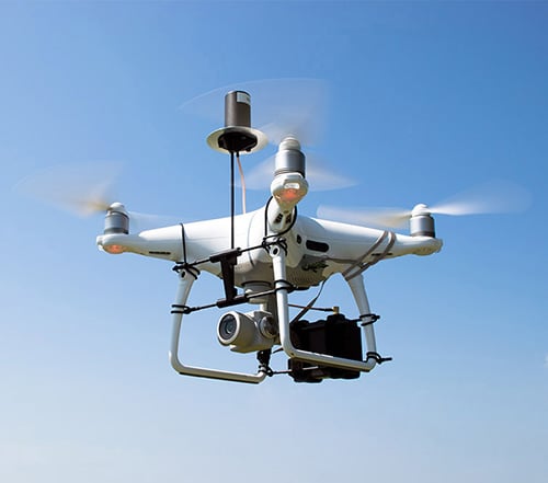
DJI Phantom 4 Pro with Loki PPK system. (Photo: GeoCue)

DJI Phantom 4 Pro with Loki PPK system. (Photo: GeoCue)

GeoCue Group (via its wholly owned AirGon subsidiary) has completed the integration of the new DJI Phantom 4 Pro RTK (P4R) into its AirGon Sensor Processing Suite (ASPSuite).

ASPSuite is a post-processing solution for GeoCue’s Loki direct geopositioning system for DJI and other manufacturer’s drones.

ASPSuite enables integration of the P4R with third-party L1/L2 GNSS base stations such as systems from Septentrio, Leica, Trimble, Topcon, CHC and others in a high accuracy post-process kinematic (PPK) workflow.

In addition to PPK processing, ASPSuite includes support for options often required in engineering-grade surveys such as:

  • vertical transforms (such as ellipsoid to country-specific geoids)
  • creation of and transformation between collection datums and local coordinate systems (site calibration)
  • application of antenna static and dynamic lever arm corrections
  • full support for Loki direct geopositioning systems.

The DJI D-RTK-2 base station (optionally available) for the P4R can only be used in RTK mode, and then only if it is being sited on a known location. The D-RTK-2 does not currently allow access to an observation file, preventing it from being stationed using an online positioning service such as OPUS, AUSPOS, Canadian Geodetic Survey services and so forth. An additional consideration in our integration into ASPSuite was that professional surveyors already have survey kit that they need incorporated into this workflow.

GeoCue is offering camera calibration services for the P4R for customers who wish to do minimal or control-free high-accuracy mapping projects (the DJI “calibration” is an image de-warping algorithm, not a proper photogrammetric calibration). A test of a GeoCue-calibrated P4R using an OPUS-positioned base station and ASPSuite achieved about 4-cm horizontal and 5-cm vertical network accuracy (RMSE) with no ground control points.


Sokkia introduces integrated receiver for diverse applications

$
0
0

Sokkia introduced the latest addition to its GNSS integrated receiver line — the GRX3. According to the company, the GRX3 is designed to provide a smaller, lighter and fully integrated GNSS solution.

Photo: Sokkia

Photo: Sokkia

“The multi-constellation GRX3 receiver is built to offer a complete and versatile solution to provide best-in-class positioning performance for a wide variety of precision applications,” said Alok Srivastava, director of product management.

“Whether using the receiver for GNSS post-processed surveying, or RTK using wireless technologies including network RTK option with a cellular-equipped field computer, a SiteComm RTK rover, or paired with a Sokkia total station for fusion positioning, the GRX3 provides the most advanced and powerful GNSS technology available in a more compact and lightweight housing that can withstand the harshest of environmental conditions. Combine it with one of Sokkia’s data collectors and field software for maximum versatility and convenience, increasing fieldwork efficiency from start to finish.”

The receiver features Sokkia Tilt technology, which includes a 9-axis inertial measurement unit and ultra-compact eCompass designed to compensate for mis-leveled field measurements by as much as 15 degrees.

“The GRX3 is designed as a ‘future-proof’ solution with an advanced GNSS chipset with Universal Tracking Channels technology that automatically tracks signals from all available and planned constellations — including GPS, GLONASS, Galileo, Beidou, IRNSS, QZSS, SBAS,” Srivastava said.

The receiver has been tested to meet IP67 certification for protection against harsh environmental weather conditions.

Inertial Sense releases RTK-INS for consumer applications

$
0
0

Dime-sized INS with RTK paves the way for high accuracy in mass-market consumer applications.

Photo: Inertial Sense

Photo: Inertial Sense

Inertial Sense has released a new micro-sized inertial navigation system (INS) with precise real-time-kinematic (RTK)-level accuracy. The company says the new solution paves the way for high accuracy in mass-market consumer applications.

The new micro INS with RTK solution offers an accuracy of 2-3 centimeters using GPS positioning in combination with inertial sensors (including on-board sensor fusion).

Inertial Sense designs and manufactures precision INS+RTK GPS sensors that deliver fast, accurate and reliable altitude, velocity and position for a wide range of autonomous vehicle applications, the company said.

The new micro INS with RTK provides a high degree of precision for orientation and GPS in a tiny package. Standard INS/GPS sensors offer accuracy in the range of 1.5 to 2 meters. Inertial Sense’s micro INS with RTK offers accuracy of 2-3 centimeters.

In the image above, a vehicle travels under an overpass. The 3-cm accurate RTK-inertial navigation track holds true to the vehicle’s position while the standard GPS signal is lost. (Image: Inertial Sense)

In the image above, a vehicle travels under an overpass. The 3-cm accurate RTK-inertial navigation track holds true to the vehicle’s position while the standard GPS signal is lost. (Image: Inertial Sense)

“The incredibly small size of our new micro INS with RTK sensor, in combination with its extremely affordable price point, will make this type of highly sophisticated technology accessible for general consumer applications for the very first time,” said Walt Johnson, founder and CTO, Inertial Sense. “We are offering RTK at a size, accuracy and price point that the market has never seen before.”

By optimizing the manufacturing processes for high volume applications, the micro INS with RTK sensor is as small and lightweight as a dime, and is available at a low price point.

Sensor fusion. Sensor data from MEMs gyros, accelerometers, magnetometers, barometric pressure and u-blox GPS/GNSS are fused to provide optimal position estimation. Data out includes angular rate, linear acceleration, magnetic field, barometric altitude and GPS time.

The miniature module provides orientation, velocity and position. Base station corrections data can be applied to achieve centimeter-level precision.

Autonomous vehicles. The sensor will enable the navigation of all types of autonomous vehicles with a very high degree of precision, Inertial Sense said.

Inertial Sense patented modules are currently being sold worldwide at volume for a broad variety of applications including:

  • Autonomous navigation: Drones, ground robotics, precision ag, automobiles
  • Aerial surveys: UAV Payloads for 3D mapping, photogrammetry, orthomosaics
  • Gimbal stabilization and antenna pointing
  • 3D motion capture and personnel tracking

Evaluation kits. Inertial Sense has bundled evaluation kits it says are simple to use and contain everything needed to begin logging RTK-accurate data. The evaluation boards can be utilized in both rover and base station configurations and include 900-mhz radios with onboard logging capabilities.

Yuneec provides RTK on commercial hexacopter H520

$
0
0
Photo: Yuneec

Photo: Yuneec

Yuneec International’s commercial hexacopter, the H520, will now optionally be available with an RTK (real-time kinematic) system from the Swiss company Fixposition.

Under difficult GPS conditions, such as in cities or canyons, the RTK system ensures maximum precision and centimeter-precise positioning. The fully integrated RTK satellite navigation enables extremely accurate recurring images and faster 3D mapping. It also makes automated inspection flights easier and more precise, the company said.

The new H520 RTK is suitable for commercial applications that require maximum precision. By using RTK technology, the H520 can now fly much closer to objects for inspection as the UAV positions itself precisely in the centimeter range (1 cm + ppm horizontal / 1.5 cm + ppm vertical) rather than in the meter range, which is standard for the H520.

This accuracy is paramount for applications where several images need to be taken at the same location on different days including:

  • documenting progress on construction sites,
  • inspecting mountain landscapes to prevent natural hazards such as rock falls or avalanches, and
  • forensic accident scene reconstruction.

In addition, the satellite navigation system makes it possible to significantly reduce image overlaps, which means fewer photos and shorter model calculation times, maximizing efficiency in workflows.

The RTK system is not only fully integrated into the hardware, but also into the UAV’s software. This means the user retains the full range of functions of the DataPilot software, including mission flights.

The H520 RTK works with two components: the RTK module on board the H520 and a base station on the ground. For precise navigation, the module supports constellations of up to three different satellite systems from GPS, GLONASS, Galileo and BeiDou.

If the use of a ground station is not possible, the system can also be operated with a national reference station network (network RTK). The network RTK is provided by third-party providers and requires an internet connection, such as a mobile hotspot. All data including satellite data is recorded, which makes the H520 RTK suitable for post-processed kinematics (PPK).

The H520 RTK will be available in the second quarter of 2019. Technical specifications are available here.

Global GNSS launches survey application

$
0
0
Image: Global GNSS

Image: Global GNSS

Global GNSS, a subsidiary of Polosoft Technologies, has launched a new mobile application named GNSS Surveyor, which is designed for the geospatial industry.

The application GNSS Surveyor provides location information and quality position data in real-time with sub-meter to centimeter accuracy. It needs to be connected to any external GNSS receiver via Bluetooth.

Features of the application include:

  • A one-touch configured command to communicate directly with the GNSS Bluetooth device.
  • Location information and quality of the position data in real-time with centimeter accuracy.
  • GPS data such as position, height, satellites and velocity.
  • Constellation information for GPS, GLONASS, Galileo, BeiDou, QZSS and SBAS satellites in the orbit.
  • Direct IP feature for RTK corrections data.
  • DMS to DD conversion or vice versa.

Real-time kinematic (RTK) correction data can be forwarded to a high-accuracy external device. The internal NTRIP client loads the RTCM data from the internet.

With GNSS Surveyor, location information is collected as latitude and longitude, altitude, speed or pace, bearing and UTC time.

GNSS precision includes global coverage, centimeter-level accuracy, fast time to first fix, multi-constellation and multi-band, and highest security, the company said.

Navigation uses include ground robotics navigation, lane-level navigation, heavy machine navigation, industrial navigation and tracking and commercial UAV.

GNSS Surveyor can be downloaded from the app store.

Maxtena launches GNSS antenna for high-precision and autonomous applications

$
0
0

Maxtena Inc. has introduced a patented GNSS antenna designed for high-precision and autonomous multi-frequency applications. The M7HCT-A-SMA antenna is a high-accuracy, multi-frequency active quadrifilar helix GNSS antenna.

Photo: Maxtena

Photo: Maxtena

Maxtena is a U.S.-based antenna design and manufacturing company and inventor of the patented Dynamic Aperture Technology.

The new design will offer concurrent GNSS reception on L1: GPS, GLONASS, Galileo, Beidou and L2: GPS L2C, Galileo E5B and GLONASS L3OC in a rugged, compact and ultra lightweight form factor.

The antenna is designed for GIS, RTK and other high-accuracy GNSS applications such as the drone and automotive markets, where high performance and low weight are driving features in antenna selection.

The M7HCT-A-SMA active helix design features Maxtena’s patented compact and lightweight Helicore technology. This technology provides exceptional pattern control, polarization purity and high efficiency in a very compact form factor.

The antenna offers up to 30-dB gain for GNSS applications that utilize GPS, GLONASS, Galileo and Beidou, in one radome housing with a single SMA connector.

The M7HCT-A-SMA will join Maxtena’s line of rugged GNSS helix antennas that are ultra lightweight, small, and precise. The M7HCT-A-SMA weighs 25 grams and is housed in automotive grade PCB plastic with automotive grade electronics and is rated IP67 when mounted.
It is ground plane independent and offers extremely low power consumption and minimal phase-center variation over azimuth. The antenna offers superb axial ratio ensuring multipath error is mitigated.

“Maxtena is very excited to be launching a game-changing antenna for the UAV, drone, and automotive markets, and really for any application requiring a high performance, lightweight antenna that can cover so many frequencies. It is the most robust antenna solution on the market,” said Maxtena Vice President of Sales and Marketing Vanja Maric.

Emlid launches Reach RS2 centimeter-accurate RTK GNSS receiver

$
0
0

Emlid, the creators of Reach, centimeter-accurate RTK GNSS receiver, is now taking pre-orders for its multi-band GNSS receiver Reach RS2. The new receiver features a built-in LoRa radio, a 3.5G modem, and a survey app for iOS and Android.

Photo: Emlid

Photo: Emlid

L1/L2/L5 RTK GNSS receiver with centimeter precision. Reach RS2 determines a fixed solution in seconds and provides positional accuracy down to several millimeters. The receiver tracks GPS/QZSS (L1, L2), GLONASS (L1, L2), BeiDou (B1, B2), Galileo (E1, E5) and SBAS (L1C/A), and reliably works in RTK mode on distances up to 60 kilometers and 100 kilometers in PPK mode. A multi-feed antenna with multipath rejection offers robust performance even in challenging conditions.

RINEX raw data logs are compatible with OPUS, CSRS-PPP, AUSPOS and other PPP services so users can now get centimeter-precise results any place on Earth.

Built-in 3.5G modem and UHF LoRa radio. The Reach RS2 features a power-efficient 3.5G HSPA modem with 2G fallback and global coverage. The corrections can be accessed or broadcast over NTRIP independently, without relying on internet connection on a smartphone.

For remote areas, the Reach RS2 has a built-in LoRa radio that has proven to be a reliable link for RTK corrections for distances up to 8 kilometers.

Designed for Tough Conditions. The Reach RS2 is engineered to be waterproof and impact-resistant. Its body is manufactured in a two-step injection process and is made out of shockproof polycarbonate covered in a special elastomer for extra protection. The receiver has an industry-standard 5/8-inch mounting thread.

The LiFePO4 battery of the Reach RS2 is designed for 16 hours of work as a 3.5-G RTK rover on one charge regardless of weather conditions. It can charge from a USB wall charger or a power bank over USB-C.

A RS232 interface allows users to connect the Reach RS2 directly to external hardware and output position in NMEA.

Photo: Emlid

Photo: Emlid

ReachView App. The Reach RS2 comes with a mobile app, ReachView for iOS and Android, that is used to control all the features of the device. Users can create projects, collect and stake-out points, and import and export geodata in industry-standard formats such as CSV, DXF and Esri Shapefile.

The Reach RS2 comes in a carrying bag with a USB-C cable and a LoRa radio antenna. The ReachView app is available for download from Play Market or App Store.

Shipping of the first batch starts in mid-June 2019.

See the full specs and pre-order Reach RS2 on Emlid website.

Research Roundup: Design and evaluation of integrity algorithms for PPP in kinematic applications

$
0
0

By Kazuma Gunning, Juan Blanch and Todd Walter, Stanford University, and Lance de Groot and Laura Norman, Hexagon Positioning Intelligence

UAV and autonomous platforms can greatly benefit from an assured position solution with high integrity error bounds. The expected high degree of connectivity in these vehicles will allow users to receive real-time precise clock and ephemeris corrections, which enable the use of precise point positioning (PPP) techniques.

Until now, these techniques have mostly been used to provide high accuracy, rather than focusing on high-integrity applications. The authors apply the methodology and algorithms used in aviation to determine position error bounds with high integrity (or protection levels) for a PPP position solution.

PPP techniques can provide centimeter accuracy without local reference stations in kinematic applications. These techniques have so far mostly been used to provide high accuracy, and it is only recently that they have been proposed to provide integrity, that is, position error bounds with a very low probability of exceeding them.

There has been preliminary work on the application of integrity to PPP, but it remains a challenge to translate the benefits of PPP to accuracy while maintaining high integrity. Most of the integrity work in PPP and real-time kinematic (RTK) has dealt more with the ambiguity resolution process under nominal error conditions and less on the integrity of the position solution under fault conditions.

The authors overview their PPP filter implementation, and describe the threat model as well as two classes of integrity algorithms: solution separation and sum of squared residuals based (also called residual-based [RB], a misnomer, as all autonomous integrity monitors are based on the residuals.)

They present data sets used to evaluate the algorithms, compare the protection levels (PLs) obtained with different algorithms, and present the results obtained with the most promising PL formulation in four different data sets: static, dynamic in open-sky conditions, dynamic in midtown suburban conditions, and in flight.

Concluding, they state: “We have formulated RAIM protection-level formulas using either solution separation or the sum of residual squares. Both formulations consist of straightforward adaptations of snapshot RAIM to a Kalman filter solution.
“For solution separation, we have shown an implementation where the computational cost of running a bank of filters is far from being proportional to the cost of one filter. Instead, we could run 50 additional filters for the cost of one.

“For residual based RAIM we have developed a set of formulas to update the sum of square residuals from one time step to the next one. Because this test statistic is exactly the same as the one used in snapshot RAIM (when we consider the problem as a batch least squares), we could use the formula that ties the slope of a fault mode to the standard deviation of the solution separation. The slope can therefore also be updated recursively.”

Finally, “we have refined the PPP filter, added one scenario (suburban driving conditions), and examined the effect of considering multiple faults in the formulation of the test statistics and the protection levels. The results are very promising: protection levels below 2 m appear to be achievable, and the computation load is lower than expected.”

This paper was presented at ION-GNSS+ 2018. See www.ion.org/publications/ browse.cfm.


New u-blox module aimed at lane accuracy in urban areas

$
0
0
The ZED-F9K module is designed to keep cars in their lanes. (Photo: u-blox)

The ZED-F9K module is designed to keep cars in their lanes. (Photo: u-blox)

The new u‑blox ZED-F9K GNSS and dead-reckoning module is designed to bring continuous lane accurate positioning to challenging urban environments.

The module offers both high-precision multi-band GNSS and inertial sensors. It combines the latest generation of GNSS receiver technology, signal processing algorithms and correction services to deliver down to decimeter-level accuracy within seconds, addressing the evolving needs of advanced driver-assistance systems (ADAS) and automated driving markets.

The ZED-F9K builds on the u‑blox F9 technology platform. Compatibility with GNSS correction services further improves positioning accuracy by compensating ionospheric and other errors.

The real-time kinematic (RTK) receiver module receives GNSS signals from all orbiting GNSS constellations. The greater number of visible satellites improves positioning performance in partially obstructed conditions, while increased satellite signals delivers faster convergence times when signals are interrupted.

Inertial sensors integrated into the module constantly monitor changes in the moving vehicle’s trajectory and continue to deliver lane accurate positioning when satellite signals are partially or completely obstructed, as is the case when the vehicle is in parking garages, tunnels, urban canyons or forested areas.

When satellite signals become available again, the module combines inertial sensor data with GNSS signals to deliver fast convergence times and high availability of the decimeter-level solution.

The result of this combination of the latest developments in GNSS technology, correction services and inertial sensing is a tenfold increase in positioning performance over standard precision solutions, according to u-blox.

By robustly providing lane accurate position information, the ZED‑F9K meets the needs of ADAS and autonomous driving applications, as well as head units and advanced navigation systems. The module’s accuracy and low latency also makes it suitable for automotive OEMs and Tier 1 automakers developing V2X (vehicle-to-everything) communication systems. By continuously sharing their location with other traffic participants, V2X systems contribute to increasing overall road safety and reducing traffic congestion.

“We designed the ZED-F9K to be a turnkey high-precision GNSS solution that caters to the needs of today’s and tomorrow’s connected cars,” said Alex Ngi, product manager, product strategy for dead reckoning, u‑blox. “The ZED-F9K is unique in that it integrates a multitude of technologies, from the GNSS receiver to the inertial measurement unit and relevant dead reckoning algorithms into a single device for which we can ensure performance throughout the customer product development cycle.”

Samples will be available upon request by July.

Surveying and BYOD: Yes, you can use your smartphone

$
0
0

BRING YOUR OWN DEVICE (BYOD) is not just an industry buzzword. It can change the way professional surveyors work every day. The idea of using a smartphone or tablet instead of a dedicated device is appealing. But is it good enough?

Surveyors and mappers are challenged with the arduous task of data collection that meets accuracy and precision standards and provides adequate attribute information for the project. Before the invention of the electronic data collector, handwritten notes in field books were the norm. Every note keeper’s style varied in content, neatness and thoroughness. Calculations for determining survey data values were completed longhand on paper and were very time consuming.

History of Surveyors and Data Collectors

Like its personal computer counterpart, the electronic data collector was introduced in the late 1970s with minimal adoption by the average surveyor because of cost and complexity. Storage methods for the era included magnetic modules and tape; both forms of media were expensive and fragile with little storage for the cost.

Data collection was limited to numeric values only, with horizontal and vertical angles, slope distance, point number and point code being the extent of the information. Couple this process with the limited availability of printers and plotters capable of depicting the data for the surveyor’s use, and one can see why few practitioners invested in these systems.

iOS aerial viewer. (Screenshot: Tim Burch)Photo:

iOS aerial viewer. (Screenshot: Tim Burch)

The 1980s and 1990s brought significant changes to surveying with the advancing technology of electronic computing and measuring. The introduction of robotic total stations, various methods of GNSS, and even leveling took advantage of significant computer power and measuring processes, and the data collector stayed in lockstep with the advancing instrumentation. Almost every equipment manufacturer developed their own proprietary data collector and software system because of the unique design and programming of their systems.

In the 2000s and later, third-party manufacturers began producing data collectors with advanced computing power and the ability to connect to varying brands of equipment. Most of the programming for these collectors are still proprietary in nature to this day.

Also during the 2000s, a new wave in mobile communications was taking place. Cellular phone and data signals were now being used to transmit an abundance of information between users.

The rapid development of handheld communication devices has led to the meteoric rise of two specific mobile operating systems: one by a radical startup that concentrated on dominating the search engine market, and the other by an avant garde computer company looking to expand its unique customer base.

By the end of the decade, the world had been introduced to the Android operating system by Google, and the iOS operating system by Apple. The combined market share for the two operating systems at press time was just under 98 percent of all mobile devices worldwide.

Trending Away from Proprietary Data Collectors

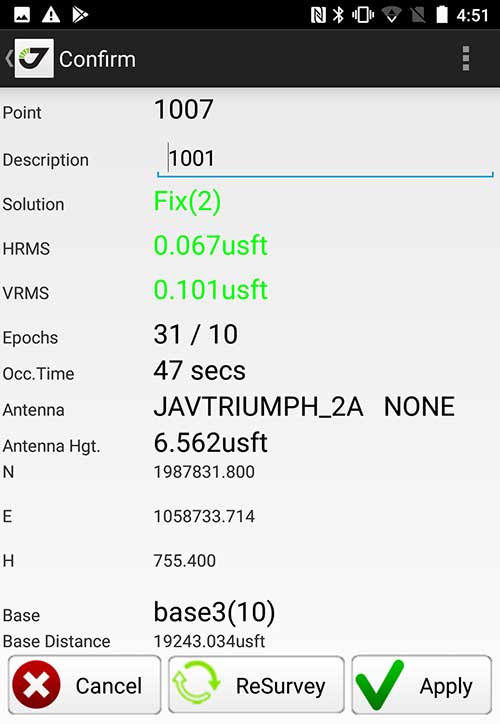
Android Point Info: Confirmation of collected data, including equipment and base station. (Screenshot: Tim Burch)

Android Point Info: Confirmation of collected data, including equipment and base station. (Screenshot: Tim Burch)

Because data collection by surveyors and mappers have traditionally been performed on proprietary systems designed and produced by equipment manufacturers for use with only their instruments, these collectors, while very powerful and robust, are costly for the equipment manufacturers to produce because of the limited market of surveyors and mappers.

Many suppliers, before the introduction of the iPhone and Android operating systems, attempted to adapt their data-collection platforms to wider recognized mobile operating systems (for example, Windows CE/Pocket PC/Mobile) on a bevy of mobile devices (HP/iPAQ, Sony Eriksson, HTC) with little success. Various versions of Windows are still being used today by GNSS equipment manufacturers’ proprietary data collectors, including Trimble, Hemisphere GNSS, Topcon and CHC Navigation.

However, the field of operating environments has become more crowded as technology continues to advance. The proliferation of Windows-based data collectors are now on the decline.

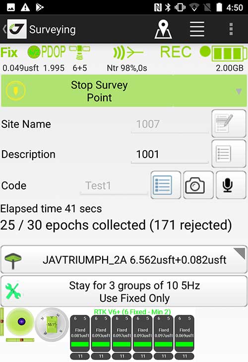
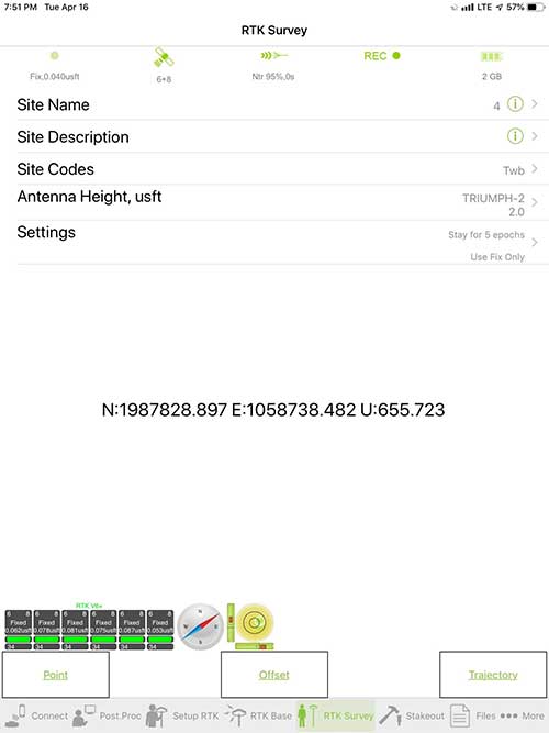
Survey Point: Status of survey data collection and GNSS engine signal reception. (Screenshot: Tim Burch)

Survey Point: Status of survey data collection and GNSS engine signal reception. (Screenshot: Tim Burch)

Enter Android and iOS. Driving the decline of the previously popular Windows mobile platform is the rapid adoption of the iOS and Android operating systems. These two environments have also led to a substantial number of devices and applications for users.

Part of the reason for the speedy acceptance of the devices and operating systems has been the ease of programming. It is estimated that each operating system has more than two million applications in their respective online stores, with more being introduced daily.

Because of the proliferation of smartphones, nearly everyone is familiar with the look, feel and operation of touchscreen devices and their various applications. This familiarity is driving a new trend in data collection: the concept of “bring your own device” (otherwise known in IT security circles as “BYOD”). BYOD is being introduced by several surveying and mapping equipment manufacturers as an alternative to their proprietary data-collection devices.

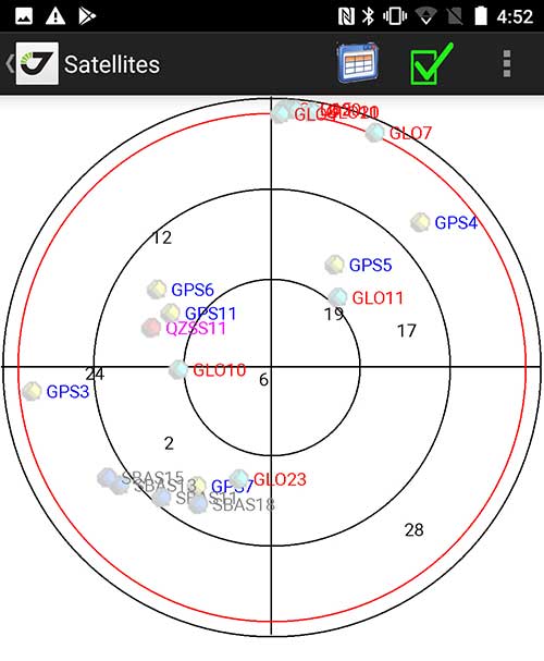
Sky Plot: Where the ‘birds’ are in the sky. (Screenshot: Tim Burch)

Sky Plot: Where the ‘birds’ are in the sky. (Screenshot: Tim Burch)

These manufacturers are pairing iOS and Android developers with their hardware and firmware specialists to create a user-friendly interface that will function on most of the most popular handheld devices on the market today. From Apple iPhones and iPads to Samsung Galaxy phones and tablets, these applications give the surveyor the best of two worlds — sophisticated data-collection capability on a well-known and reliable mobile operating system platform.

The Android platform is becoming especially popular in the handheld mapping market segment. Current users of this environment include Hemisphere GNSS, CHC Navigation, Tersus GNSS and Trimble.

The iOS applications, while not quite as prevalent as Android, are being embraced by several significant GNSS manufacturers, including JAVAD GNSS and Eos Positioning Systems.

These companies are creating iOS and Android apps that embrace the BYOD market, providing their users with affordability and creating a comfort level simply because of the familiarity of the device and its environment.

How Good Is It?

iOS Position. Status of survey data collection and GNSS engine signal reception. (Screenshot: Tim Burch)

iOS Position. Status of survey data collection and GNSS engine signal reception. (Screenshot: Tim Burch)

For the surveyor to be satisfied with the operation, the collection process must be efficient, cost-effective and easy to use. For this explanation of key items within a well-rounded data-collection application, we are using the JAVAD Mobile Tools (now J-Mobile) application built specifically for the Android and iOS operating systems.

The Android system (Version 7.0) was installed on a rugged CAT S41 cellphone made Bullitt Group from the United Kingdom, while the iOS app was used on the author’s iPad Air 2 running Version 12.2. Both apps were utilized in conjunction with the JAVAD Triumph-2 GNSS receiver.

After putting both versions through trial testing and checking against values on known monuments, here is the results of our findings:

Receiver Setup. Visual reference for leveling and direction of GNSS receiver. (Screenshot: Tim Burch)

Receiver Setup. Visual reference for leveling and direction of GNSS receiver. (Screenshot: Tim Burch)

Data Organization. Easy to comprehend and flexible for most naming conventions.
Corrections and Sources. Easily connects to base receiver and radio or available NTRIP correction service for real-time network (RTN) capability.

Sky Plot. Because the Triumph-2 is equipped to receive most of the available satellites in service, the Sky Plot feature is beneficial to the user for assessing potential interference.

File Management, Import and Export. Covers the typical file management and transfer functions used by the surveyor.

RTK Survey Operations. Robust telemetry keeps the users informed of specific satellite data and correction status.

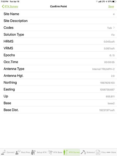
Point Confirmation. Survey point information with metadata and equipment listing. (Screenshot: Tim Burch)

Point Confirmation. Survey point information with metadata and equipment listing. (Screenshot: Tim Burch)

Coordinate Systems. All standard coordinate systems are included with features to allow the user to customize their own systems.

Localization. Creation of a local coordinate system is a simple routine, providing strong quality checks for data integrity.

Lift and Tilt. This feature provides the user with a useful procedure to end data collection without the need to press a button. This feature significantly increases the user’s productivity.

Compass and Level Calibration. With the Triumph-2 having an internal compass and level system, status of the receiver is graphically displayed to help the user keep a close watch on the accuracy of the survey point.

Survey Points and Linework. Most point naming systems and line-coding procedures are easily adapted.
Total Station Point Transfer. The creation of control point files for transfer to total stations is simple and easy to use.

Stakeout. Graphical status screens provide the user with simple plotting capability of the desired stakeout point to increase efficiency and accuracy.

These apps are good at providing the surveyor with a solid tool for data collection and staking capability. They are especially good when paired with a real-time kinematic
(RTK) base station or NTRIP correction service.

But what happens when cell service is not readily available, or there are no published monument coordinates to establish site control? These apps have the surveyor covered for that situation as well.

Post-Processing (OPUS and DPOS)

Today’s surveyor works in an environment where geographic-based data is a key component to the services they render to their clients. While most of the world’s developed nations have access to cellular networks in which most GNSS receivers can communicate with an RTN providing corrective solutions, the places where this is not possible relies on other means of data correction.

In the U.S. we rely on OPUS (Online Post-Processing User System) to provide that service. But, as good as it is, it has limitations. Currently, it only utilizes GPS satellite data from the U.S. Department of Defense and is subject to sporadic government shutdowns.

Other services, from both public and private sources, are in place around the world to provide a service similar to OPUS. These include, but are not limited to:

  • AUSPOS. Geoscience Australia (free)
  • APPS. Jet Propulsion Laboratory at California Institute of Technology (free)
  • CSRS-PPP. Natural Resources Canada (free)
  • GAPS. University of New Brunswick (free)
  • magicGNSS. GMV (free)
  • Centerpoint RTX Post Processing. Trimble (free)
  • JAVAD Data Processing Service (DPOS). JAVAD (free, processes any JAVAD GNSS jps file)

These correction services utilize other satellite constellations (GLONASS, Galileo, BeiDou and QZSS) for their solutions and can provide additional coverage, depending on the location of the user. Because of these services, geographic-based data is at the fingertips of surveyors worldwide.

JAVAD’s DPOS system is has the ability to collect static survey data and send it to the proprietary service for establishing new coordinate values for base-station use. This process is a function of the app and can be completed in a few short steps.

Once the base station values are calculated, the surveyor can make use of this information for establishing a base station for correction broadcasting.

Do You Need a Base Station?

The establishment of RTNs has greatly enhanced surveying capability as cellular service has increased in coverage and speed. However, there are still instances and locales that do not allow for the reliable use of cell signals to provide those corrections accurately.

Various manufacturers’ tests have proven the accuracy of using an RTN subscription versus the traditional GNSS base and rover RTK setup. But cell-signal strength can be an Achilles heel, crippling those who choose not to set up a base station.

The UHF radio, even in its reduced power state from regulatory changes, is still more powerful and reliable than most cell services. 5G technology and coverage is anticipated to revolutionize cellular service, but it has yet to be realized.

Adaptation of the Industry

Other GNSS manufacturers (including NovAtel, Navcom, ComNav, Unicore, Emcore, Suzhou, TeleOrbit and Geneq) are producing receivers that can be adapted to a variety of existing data collectors and connect to iOS/Android mobile devices through various software developers.

The future of communications remains the smartphone or tablet device, with foldable units expected to be the next big thing.

As processors get more powerful, as chip memory becomes more abundant, and as more satellite constellations orbit in our sky, surveyors and their data collectors will continue to evolve. The future remains bright for technology and the surveyor has a front-row seat.


TIM BURCH is GPS World’s contributing editor for Survey. A professional land surveyor with more than 30 years of experience, he is director of surveying at SPACECO Inc. in the Chicago area. For several years he has been secretary and was recently named vice-president of the Board of Directors of the National Society of Professional Surveyors. He writes a bi-monthly column in the Survey Scene e-newsletter. Subscribe free at www.gpsworld.com/subscribe.


Receiver, Software Ready for Mobile

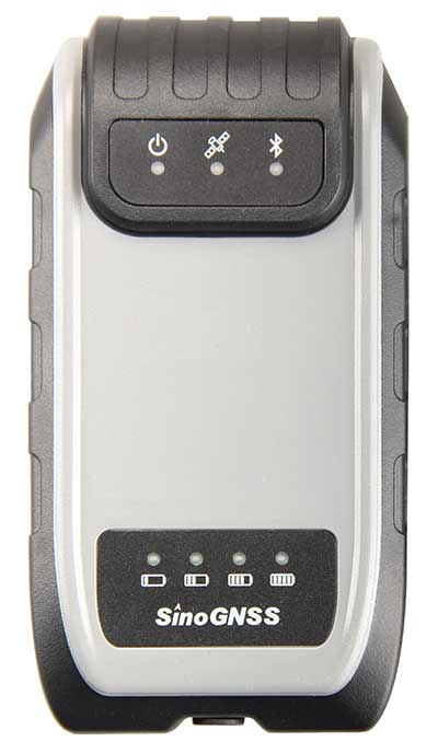
Photo: ComNav

Photo: ComNav

ComNav receivers offer multiple data-collection device choices via Bluetooth connection, as well as an Android app.

For instance, the G200 provides centimeter-accuracy positioning to any connected mobile devices for RTK field surveying. It is able to delivery robust survey workflows with the SinoGNSS Android-based Survey Master, so that surveyors can collect quality high-accuracy positions no matter what mobile device they are using.

The G200 is a rugged, compact, wearable GNSS receiver. Combined with the high-performance SinoGNSS OEM board tracking GPS L1/L2, BeiDou B1/B2, GLONASS L1/L2, Galileo and QZSS, the G200 enables reliable high-precision GNSS performance for land survey tasks anywhere in the world.

TerraStar Gives Assist to RTK

Photo: Leica Geosystems

Photo: Leica Geosystems

NovAtel offers several levels of corrections via its TerraStar service. For surveying applications, the RTK Assist service provides correction data to bridge surveyors through any real-time kinematic (RTK) correction outages. TerraStar services work on NovAtel’s OEM6 and OEM7 receivers..

RTK Assist, available on OEM6/OEM7 receivers, provides 20 minutes of RTK assistance, enabling surveyors to maintain centimeter-level accuracy. A higher service level, RTK Assist Pro, is available on OEM7 receivers. It provides unlimited RTK assistance with stand-alone centimeter-level positioning when RTK is not available.

Trimble Offers Web-Based Post-Processing

Photo: Trimble

Photo: Trimble

Trimble’s CenterPoint RTX Post-Processing Service is a free, web-based solution that provides rigorous processing of GNSS data for users around the globe.

Powered by advanced algorithms for processing static observations, CenterPoint RTX Post-Processing supports data including GPS, GLONASS, Galileo, BeiDou and QZSS. With the service, users can upload GNSS data using Trimble formats or industry-standard RINEX 2 and RINEX 3. The service supports all dual-frequency GNSS receivers and more than 400 different antennas.

The post-processing service computes single-station static observation sessions ranging in length from 10 minutes up to 24 hours, with longer observation sessions recommended to produce the highest accuracy. Using data from the global RTX tracking network, the CenterPoint RTX Post-Processing service computes the position of the observed point with centimeter accuracy.

Results are delivered via email in ITRF coordinates at the current epoch and can be transformed to a fixed epoch by use of a standard tectonic-plate model.

Atlas Corrections Ready for BYOD

The Atlas GNSS global correction service, offered by Hemisphere GNSS, provides correction data for GPS, GLONASS, BeiDou and Galileo constellations. Its global L-band corrections allow for accuracies ranging from sub-meter to sub-decimeter levels. The network has more than 200 reference stations worldwide and covers virtually the entire globe.

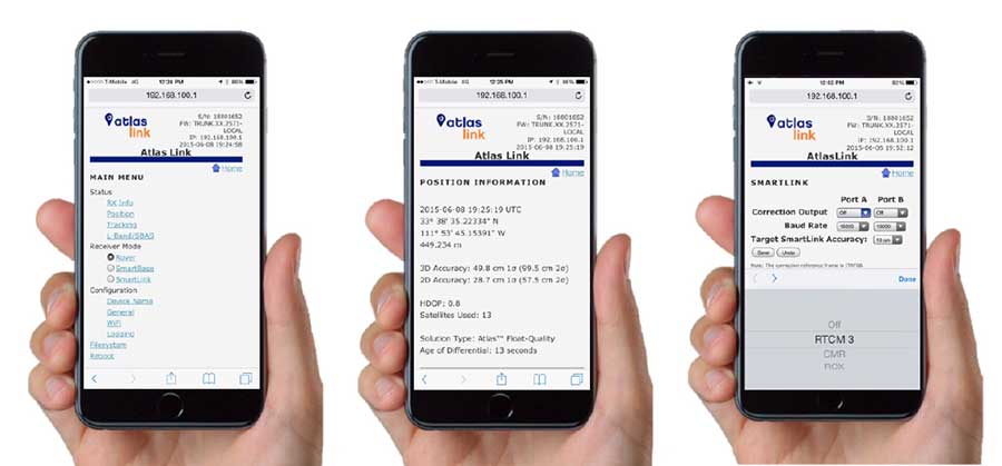
Examples of how the AtlasLink webUI looks on a smartphone. (Image: Hemisphere GNSS)

Examples of how the AtlasLink webUI looks on a smartphone. (Image: Hemisphere GNSS)

The Atlas platform was conceived to enable as many people as possible to have access to the correction service technology, either as an end-user or as part of their business. Several features are designed to enable customers who use non-Hemisphere positioning systems to have access to Atlas.

For instance, Hemisphere’s SmartLink technology allows an AtlasLink GNSS smart antenna to be used as an Atlas signal extension for any GNSS system compliant with open communication standards.

Hemisphere’s GNSS smart antennas including AtlasLink, A326, C321+ and S321+ offer a user-friendly web user interface (WebUI) that can be used to configure, monitor and manage the receiver from virtually any modern computing device, including computers, phones and tablets.

SoftBank goes hard on autonomous positioning in Japan

$
0
0

SoftBank plans to introduce a centimeter-accurate, real-time satnav-based positioning service, specifically using Japan’s Quasi-Zenith Satellite System (QZSS), to guide autonomous vehicles across a range of industries in Japan. The company said it will install more than 3,300 control points at base stations across Japan to deliver centimeter-level accuracy over its mobile network coverage area to provide real-time kinematic (RTK) positioning.

Testing begins in July with a scheduled launch of commercial service by the end of November. Test partners include Yanmar Agribusiness Co., Ltd., a provider of autonomous assisted driving for agricultural machinery, Kajima Corporation, which performs construction site management with automatically controlled drones for aerial photography and monitoring, and SB Drive Corp., a provider of autonomous and assisted driving technology for buses.

SoftBank is developing proprietary low-cost GNSS receivers so that “new services and market expansion can be realized.” A Positioning Core System provided by ALES Corp. will generate correctional data based on signals received and transmitted by SoftBank’s own control points over SoftBank’s mobile communications network to agricultural and construction machinery, self-driving cars, drones and other equipment carrying GNSS receivers. The company expects that centimeter-level positioning can thus be done in real time.

In addition to control points at its own base stations, SoftBank will use the Geospatial Information Authority of Japan’s approximately 1,300 GPS-based control stations.

SoftBank is also developing services to enablec loud-based RTK positioning for devices without GNSS receivers. Cloud-based RTK will provide centimeter-level, location-based services for equipment that needs to be miniature and energy-efficient, such as infrastructure surveillance sensors and wearable devices.

SoftBank Group Corp. is a Japanese multinational conglomerate holding company headquartered in Tokyo. It owns operations in broadband, fixed-line telecommunications, e-commerce, internet, technology services, finance, semiconductor design and more. It is the 36th largest public company in the world, and the 2nd largest in Japan.

ALES is a joint venture established by SoftBank and Enabler in July 2018. Enabler employs GNSS and related technologies to produce such products/services as a synchronization solution for mobile base stations for subway stations and a patented indoor positioning/time synchronization infrastructure platform in Japan.


Featured image: Softbank

Allystar offers dual-antenna GNSS-aided INS platform

$
0
0

The Allystar INS Platform — the company’s latest technology — is a dual-antenna, multi-frequency, multi-GNSS inertial navigation system (INS) that delivers accurate and reliable position, velocity and orientation, the company said.

It is designed for a wide range of autonomous vehicle applications under the most demanding conditions.

Allystar RTK/INS Evaluation Board V1.0. (Photo: Allystar)

Allystar RTK/INS Evaluation Board V1.0. (Photo: Allystar)

The Allystar INS Platform combines high-grade, six-axis, temperature-calibrated accelerometers and gyroscopes with a multi-frequency, multi-GNSS engine, the HD9300 series. HD9300 is a dual-antenna chip-grade real-time kinematic (RTK) GNSS receiver for accurate positioning and heading.

GNSS-aided inertial navigation systems are widely used in autonomous vehicles. However, high-accuracy multi-frequency multi-GNSS receivers are usually too expensive for mass-market applications. The Allystar HD9300 series is a mass-market multi-band chip-grade receiver that concurrently support all civil bands in all GNSS constellations (GPS/QZS L1&L2&L5&L6, BDS B1&B2&B3, GAL E1&E5, GLO L1OF/L2OF) with an integrated RTK engine to achieve centimeter-level accuracy.

The Allystar INS platform contains an on-board sensor-fusion filter, navigation and calibration algorithms for different dynamic motions of land vehicles. Key features include:

  • multi-band multi-GNSS chip-grade receiver
  • dual antennas
  • integrated RTK engine (up to 2 centimeters)
  • 100-hz update rate
  • OBD data adapter.
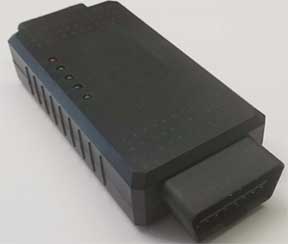
Allystar OBD Data Adaptor V1.(Photo: Allystar)

Allystar OBD Data Adaptor V1. (Photo: Allystar)

The Allystar OBD Data Adapter (v1.0) enables users to read and monitor various sensors built into cars, obtaining the real-time vehicle speed and gear signals from the OBD interface, and then output AT commands by serial port or SPI. When connected to the Allystar RTK INS platform, the adapter allows for outstanding navigation accuracy, especially in urban areas, helping to increase accuracy and reduce position drift.

An evaluation kit — including platform board, antenna and OBD adaptor — will be available in August.

CHC Navigation’s new i90 GNSS receiver improves RTK

$
0
0
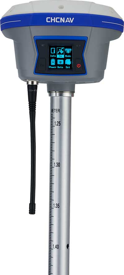
Photo: CHC Navigation

Photo: CHC Navigation

CHC Navigation has released and is immediately shipping its new i90 IMU-RTK GNSS Series receiver. The i90 IMU-RTK GNSS Series is designed to dramatically increase GNSS real-time kinematic (RTK) availability and reliability.

The i90 is powered by the company’s latest inertial measurement unit (IMU) and RTK technology to provide robust and accurate GNSS positioning in any circumstances.

Unlike standard micro-electro-mechanical (MEMS)-based GNSS receivers, the i90 GNSS IMU-RTK combines a high-end calibration and interference-free IMU sensor with a state-of-the-art GNSS RTK engine and advanced GNSS tracking capabilities.

The i90 is designed to increase productivity and reliability of survey projects. No complicated calibration process, rotation, leveling or accessories are necessary with the i90 GNSS Series. Just a few meters’ walk will initialize the i90 internal IMU sensor and enable RTK survey in difficult field environments. The i90 GNSS automatic pole-tilt compensation boosts survey and stakeout speed by up to 20%.

“Our new i90 IMU-RTK GNSS Series is pushing the boundaries of conventional GNSS survey by extending RTK positioning availability and reliability,” said George Zhao, CEO of CHC Navigation. “CHCNAV is the GNSS technology enabler, making high-end GNSS solutions available for every surveyor.”

Viewing all 129 articles
Browse latest View live